Yet somewhere along the way, the momentum faded. Historical archaeology, once a promising field, now feels paused—its questions suspended, its sites slipping back into silence. What would it take to breathe life into Kaushambi—and the kind of archaeology it once inspired?
Beneath the mounds
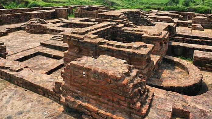
About 51 kilometres southwest of Prayagraj, on the left bank of the Yamuna river, lie the sprawling ruins of ancient Kaushambi. Spread across the villages of Kosam Inam and Kosam Khiraj, the remains were first identified by Alexander Cunningham in 1861. He followed the trails of Chinese travellers and consulted Pali texts to rediscover lost cities like Kaushambi. An Ashoka pillar with a Brahmi inscription supported his identification. Although scholars like Vincent Smith proposed alternate locations, later findings confirmed Cunningham’s conclusion.
About 70 years later, the site was briefly excavated by NG Majumdar of the Archaeological Survey of India (ASI). He conducted a small dig near the Ashokan pillar, but his findings were never published. It wasn’t until the large-scale excavations led by GR Sharma from 1949 to 1967 that Kaushambi began to reveal its secrets. These excavations focused on four main zones—the pillar area, city defences, the Ghositarama monastery, and the palace complex.
Near the Ashokan pillar, Sharma identified four cultural phases. Period I predates the Northern Black Polished Ware (NBPW); Period II includes Painted Grey Ware (PGW) sherds; Period III is dominated by NBPW; and Period IV was labelled as post-NBPW. Brick structures from around 300 BCE were found here, along with uninscribed coins and the distinctive ‘lanky bull’ coins typical of Kaushambi.
In Period III (c. 175-325 BCE), coins from the Mitra rulers were found, followed by those of the Kushanas and Maghas. By 320 CE, coins bearing the name Ganendra appeared, alongside brick walls, terracotta drains, ring-wells, and brick-concrete floors laid in mud. Houses consisted of multiple rooms arranged around a central courtyard. According to Sharma, habitation in this area ceased around 400 CE.
The city’s fortified ramparts and moats were among the excavation’s most significant discoveries. The rampart had five main gateways—two each in the north and east, and one in the west – in addition to six smaller ones. The western gate was strategically placed at the apex of a triangle formed by two projecting salients. In front of the eastern gate stood a massive mud bund, 106 metres long and 27 metres wide, possibly acting as a protective barrier. The moat, designed for emergencies, could be filled with water from nearby reservoirs, creating a defensive flood zone up to 146 metres wide.
According to Sharma, the defence was built in three phases: the first using rammed clay around the 2nd millennium BCE; the second built between 535 and 465 BCE; and the third around 185 BCE. The rampart was continually raised over time, until the Hunas destroyed the complex. Five successive road levels leading up to the rampart were also identified.
The palace complex stirred considerable interest in archaeological circles. Measuring about 315 by 150 metres, it was discovered in the fortified city’s southwest corner. Based on excavated sections, constructional styles, and material, Sharma identified three phases. The lowest revealed random rubble masonry predating the NBPW; the second featured dressed stones; and the third revealed brick walls veneered with dressed stones, dating to the post-NBPW period.
According to Sharma, the palace likely belonged to King Udayin, a contemporary of the Buddha. But this interpretation—along with the dating—later became a topic of scholarly debate.
Within the walled city stood the Ghositarama monastery. Its square-shaped main stupa was accompanied by two smaller stupas, a shrine to Hariti, and an apsidal structure flanked by two stupas at the entrance. The site witnessed 16 structural phases, beginning in the 5th century BCE. Additions in the third phase were attributed to Ashoka. By the eighth phase, cells and an inner veranda were added. The boundary wall came much later, around the 13th century CE. Like much of Kaushambi, the monastery was eventually destroyed during the Huna invasions.
Also read: South India is the missing link to our Megalithic past. And it shows history isn’t linear
Revisiting Kaushambi
In 2017, Kausambi Revisited, published by BB Lal along with A Ghosh, KK Sinha, and KV Soundara Rajan, offered fresh perspectives on Kaushambi’s key findings. Rather than discrediting Sharma, the booklet opened space for critical discourse with interpretations that had long shaped our understanding of the site.
One of the most debated topics was the dating of the palace complex, which Sharma linked to King Udayin—said to have ruled in the 6th century BCE. Lal, however, argued that what Sharma had interpreted as three building phases were actually layers within a single foundation trench.
He re-examined the section and identified a vertical foundation trench cutting through multiple occupational layers—including one associated with NBPW—suggesting Sharma’s dating was flawed. “The basic trouble,” Lal wrote, “arose out of not having recognized the foundation trench” (Lal 2017:11). He proposed that the palace complex was built in the 16th century CE, not the 6th century BCE.
Other archaeologists supported this reassessment. SP Gupta pointed to architectural fragments clearly belonging to the medieval period. MN Deshpande, during a visit, noted a stone embedded in the palace wall bearing a Devanagari inscription from the 12th or 13th century CE.
The second major issue was the dating of the city’s defences. Sharma had suggested the massive clay rampart was built around 1025 BCE, based on the presence of NBPW in nearby layers and comparisons to Harappan sites. But Lal, Sinha, Ghosh, and historian RS Sharma questioned this interpretation. Lal argued that if the rampart had been built by dumping soil, some cultural material should have been present in the fill. Ghosh, meanwhile, rejected the supposed connections to Harappan architecture and noted the absence of authentic PGW, cautioning against placing Kaushambi on the PGW distribution map.
Even elements such as the so-called altar for human sacrifice were questioned—Lal suggested it might simply be a collapsed pile of bricks.
Also read: When archaeology wasn’t ‘ladylike,’ women still shaped the field, one dig at a time
Why these debates matter
Sharma’s conclusions were rooted in the stratigraphy and the presence of marker pottery types such as PGW and NBPW. He believed the pottery from lower levels aligned with material from sites across western and central India and the Ganga valley (Sharma 2017:63) But archaeology in the 1950s was still in its early stages. Today, we recognise more regional variations in cultural material, which allows for better understanding of sites like Kaushambi in relation to their ecology and environment, rather than finding similarities with sites located miles away.
In Indian archaeology, there’s often more emphasis on finding similarities than noting dissimilarities. In Kaushambi’s case, indigenous variants—briefly hinted by Sharma—deserve deeper investigation. While earlier scholars either supported or outright rejected his claims, few investigated possible links to local trade networks.
We now also know that NBPW may not have been preceded exclusively by PGW—but could be a more accurate precursor to Black Slipped Ware (BSW), prevalent at many related sites. Moreover, dating for NBPW has changed, and interpretations need to adjust accordingly.
Ultimately, these reassessments challenge long-standing assumptions and encourage a more evidence-driven, cautious approach to interpreting complex archaeological landscapes like Kaushambi. Excavation is just the beginning—interpretations, debate, and re-evaluations are where archaeology truly comes alive.
Disha Ahluwalia is an archaeologist and research fellow at the Indian Council of Historical Research. She tweets @ahluwaliadisha. Views are personal.
(Edited by Aamaan Alam Khan)
var ytflag = 0;
var myListener = function() {
document.removeEventListener(‘mousemove’, myListener, false);
lazyloadmyframes();
};
document.addEventListener(‘mousemove’, myListener, false);
window.addEventListener(‘scroll’, function() {
if (ytflag == 0) {
lazyloadmyframes();
ytflag = 1;
}
});
function lazyloadmyframes() {
var ytv = document.getElementsByClassName(“klazyiframe”);
for (var i = 0; i < ytv.length; i++) {
ytv[i].src = ytv[i].getAttribute('data-src');
}
}